A comprehensive Site Visitor Capacity Study in 2008 identified Eurong as the most visited site on all of Fraser Island (K’Gari). It is the main hub for all the island’s visitors.
This is one of the motivations for FIDO’s intensive efforts to improve the natural integrity of this very important site by controlling the weeds. It is why FINIA chose Eurong as the site for the Demonstration Garden Project, which aims to encourage landholders and residents to grow plants native to Fraser Island on their lots rather than propagating and spreading alien plants, many of which have turned into weeds.
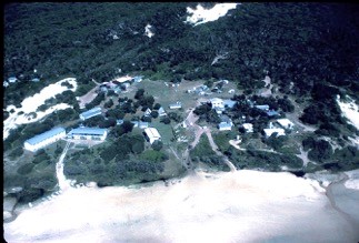
In 1963, prior to any National Park being created on Fraser Island, over 250 hectares of Eurong were set aside as a township reserve. None of this reserve, which extends 1.6 kms inland with a 1.6 km beach frontage, is included in the Great Sandy National Park. The National Park Ranger Station is not part of the township reserve. Some remarkable natural features of the township reserve include wetlands and sandblows and a diversity of ecosystems. Preserving Eurong’s natural integrity is critical to the natural integrity of the National Park that surrounds it on three sides.
Between the two valleys, one of which is occupied mainly by the resort site and the residential valley where most of the village’s houses are located, are the remnants of sandblows that were very active when the village was surveyed in 1963. After getting on top of the weeds in this Unallocated State Land, FIDO is embarking on an ambitious and most interesting project to establish an interpreted nature walk that describes the connection between climate, soil and vegetation. This will help visitors and residents to better understand the vegetation patterns and how they are largely related to soil development.
The interpretation on this fascinating easy 10 to 20-minute stroll explains one of the keys to understanding the development of the diversity of Kgari’s vegetation patterns. The impact of sandblows on Melalueca growth will be a special feature of the walk, which shows entombed and exhumed Melaluecas that may be thousands of years old.
John Sinclair (AO), FIDO
